


Rehoboth Precinct 1, Bristol County, Massachusetts
About
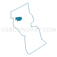
Outline

Summary
| Unique Area Identifier | 593763 |
| Name | Rehoboth Precinct 1 |
| County | Bristol County |
| State | Massachusetts |
| Area (square miles) | 15.71 |
| Land Area (square miles) | 15.63 |
| Water Area (square miles) | 0.08 |
| % of Land Area | 99.50 |
| % of Water Area | 0.50 |
| Latitude of the Internal Point | 41.89011140 |
| Longtitude of the Internal Point | -71.23805420 |
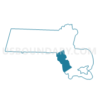
Maps

Graphs
Select a template below for downloading or customizing gragh for Rehoboth Precinct 1, Bristol County, Massachusetts


Neighbors
Neighoring Voting District (by Name) Neighboring Voting District on the Map
- Attleboro Ward 4 Precinct B, Bristol County, MA
- Attleboro Ward 5 Precinct B, Bristol County, MA
- Dighton Precinct 1, Bristol County, MA
- Norton Precinct 1, Bristol County, MA
- Rehoboth Precinct 2, Bristol County, MA
- Seekonk Precinct 1, Bristol County, MA
- Seekonk Precinct 2, Bristol County, MA
- Taunton Ward 7 Precinct B, Bristol County, MA
Top 10 Neighboring County Subdivision (by Population) Neighboring County Subdivision on the Map
- Taunton city, Bristol County, MA (55,874)
- Attleboro city, Bristol County, MA (43,593)
- Norton town, Bristol County, MA (19,031)
- Seekonk town, Bristol County, MA (13,722)
- Rehoboth town, Bristol County, MA (11,608)
- Dighton town, Bristol County, MA (7,086)
Top 10 Neighboring Place (by Population) Neighboring Place on the Map
Top 10 Neighboring Unified School District (by Population) Neighboring Unified School District on the Map
- Taunton School District, MA (55,874)
- Attleboro School District, MA (43,593)
- Norton School District, MA (19,031)
- Dighton-Rehoboth School District, MA (18,694)
- Seekonk School District, MA (13,722)
Top 10 Neighboring State Legislative District Lower Chamber (by Population) Neighboring State Legislative District Lower Chamber on the Map
- Fifth Bristol District, MA (42,781)
- Fourth Bristol District, MA (42,171)
- Second Bristol District, MA (39,600)
- Third Bristol District, MA (37,980)
Top 10 Neighboring State Legislative District Upper Chamber (by Population) Neighboring State Legislative District Upper Chamber on the Map
Top 10 Neighboring 111th Congressional District (by Population) Neighboring 111th Congressional District on the Map
Top 10 Neighboring Census Tract (by Population) Neighboring Census Tract on the Map
- Census Tract 6318, Bristol County, MA (7,579)
- Census Tract 6133, Bristol County, MA (7,201)
- Census Tract 6151, Bristol County, MA (7,086)
- Census Tract 6321, Bristol County, MA (6,543)
- Census Tract 6317, Bristol County, MA (6,471)
- Census Tract 6332, Bristol County, MA (6,118)
- Census Tract 6331, Bristol County, MA (5,490)
- Census Tract 6134, Bristol County, MA (3,812)
- Census Tract 6112.01, Bristol County, MA (3,003)
Top 10 Neighboring 5-Digit ZIP Code Tabulation Area (by Population) Neighboring 5-Digit ZIP Code Tabulation Area on the Map
- 02780, MA (49,036)
- 02703, MA (43,593)
- 02766, MA (19,031)
- 02771, MA (13,708)
- 02769, MA (11,608)
- 02764, MA (3,988)